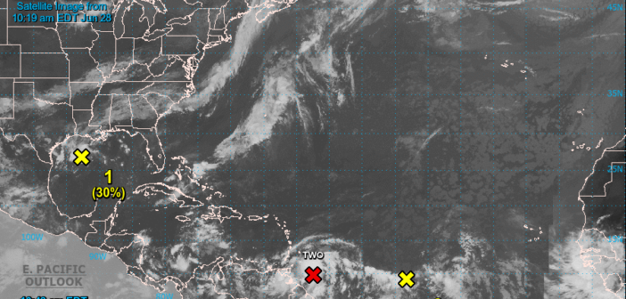
Potential Tropical Cyclone Two Advisory Number   4
NWS National Hurricane Center Miami FL       AL022022
1100 AM AST Tue Jun 28 2022

...LOCALLY HEAVY RAINS AND GUSTY WINDS BEGINNING TO SPREAD
OVER THE SOUTHERN WINDWARD ISLANDS...


SUMMARY OF 1100 AM AST...1500 UTC...INFORMATION
-----------------------------------------------
LOCATION...9.8N 57.5W
ABOUT 260 MI...420 KM E OF TRINIDAD
MAXIMUM SUSTAINED WINDS...40 MPH...65 KM/H
PRESENT MOVEMENT...W OR 280 DEGREES AT 23 MPH...37 KM/H
MINIMUM CENTRAL PRESSURE...1009 MB...29.80 INCHES


WATCHES AND WARNINGS
--------------------
CHANGES WITH THIS ADVISORY:

The government of Venezuela has issued a Tropical Storm Warning for
Islas de Margarita, Coche and Cubagua.

The government of the Netherlands has issued a Tropical Storm
Warning for Bonaire.

The government of Curacao has issued a Tropical Storm Warning for
Curacao.

The government of Aruba has issued a Tropical Storm Warning for
Aruba.

SUMMARY OF WATCHES AND WARNINGS IN EFFECT:

A Tropical Storm Warning is in effect for...
* Trinidad and Tobago
* Grenada and its dependencies
* Islas de Margarita, Coche and Cubagua
* Bonaire
* Curacao
* Aruba

A Tropical Storm Watch is in effect for...
* Coast of Venezuela from Pedernales to Cumana

A Tropical Storm Warning means that tropical storm conditions are
expected somewhere within the warning area within 36 hours.

A Tropical Storm Watch means that tropical storm conditions are
possible within the watch area, generally within 48 hours.

Interests elsewhere in the Windward Islands, the northern coast of
Venezuela, and the northeastern coast of Colombia should monitor the
progress of this system.

For storm information specific to your area, please monitor
products issued by your national meteorological service.


DISCUSSION AND OUTLOOK
----------------------
At 1100 AM AST (1500 UTC), the disturbance was centered near
latitude 9.8 North, longitude 57.5 West.  The system is moving
toward the west near 23 mph (37 km/h).  A westward or west-
northwestward motion is expected through Thursday.  On the forecast
track, the system will pass near or over portions of the southern
Windward Islands by tonight, and move over the southern Caribbean
Sea or near the northern coast of Venezuela on Wednesday and
Thursday.

Maximum sustained winds are near 40 mph (65 km/h) with higher gusts.
Some strengthening is forecast during the next few days if the
disturbance remains over water.

Conditions appear conducive for development if the disturbance
remains over water, and it will likely become a tropical storm near
the southern Windward Islands or while moving westward across the
southern Caribbean Sea.
* Formation chance through 48 hours...high ...70 percent.
* Formation chance through 5 days...high...90 percent.

Tropical-storm-force winds extend outward up to 60 miles (95 km)
from the center.

The estimated minimum central pressure is 1009 mb (29.80 inches).


HAZARDS AFFECTING LAND
----------------------
Key messages for Potential Tropical Cyclone Two can be found in the
Tropical Cyclone Discussion under AWIPS header MIATCDAT2 and WMO
header WTNT42 KNHC.

RAINFALL: The Potential Tropical Cyclone is expected to produce
heavy rain across the southern Windward Islands and the northeastern
coast of Venezuela later today through Wednesday.  The following
storm total rainfall amounts are expected:

Islands from Guadeloupe to St. Lucia: 1 to 3 inches.

St. Vincent, the Grenadines, and Barbados: 3 to 5 inches.

Grenada, Trinidad and Tobago, and northeastern Venezuela: 4 to 6
inches.

Aruba, Curacao, and Bonaire: 3 to 5 inches.

WIND:  Tropical storm conditions are expected in the warning area in
the southern Windward Islands tonight, over Islas Margarita and the
adjacent islands Wednesday morning,  and over the ABC Islands later
on Wednesday.  Tropical storm conditions are possible in the watch
area along the northeastern coast of Venezuela tonight.
![]()
Leave a comment below...


