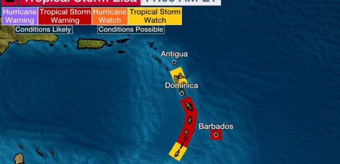
Synopsis:At 11:00 am, TS Elsa has strengthened and is centered near latitude 10.1 North, longitude 51.4 West, about 680 nautical miles east southeast of Grenada. The system is moving toward the west near 28 mph (44 km/h) with Maximum sustained winds near 45 mph (75 km/h) with higher gusts. An even faster motion toward the west-northwest is expected over the next 24 to 36 hours.
Projected track: On the forecast track, weather models indicate that the core of system will pass near or over portions of the Windward Islands or the southern Leeward Islands on Friday, just north of State of Grenada and, move into the eastern Caribbean Sea late Friday and Friday night. This system is expected to bring showers and thundershowers to Grenada and the rest of the Windward Islands on Friday.
Grenada, Carriacou and Petite Martinique can expect cloudy to overcast conditions with showers (which may become heavy) and thundershowers accompanied by gusty winds by late Friday morning into Saturday. The likelihood of significant impacts is greater for the Sister Isles of Carriacou and Petite Martinique.
The Met Office continues to closely monitor the progress of this system as it approaches the Lesser Antilles.
Potential Impacts (most significant across the northern section of the state)
– Medium chance of flash flooding
– Downed trees and powerlines
– Landslides and rock fall
Tropical storm warning has been issued forBarbados, Martinique, St. Vincent and the Grenadines, and St. Lucia. GRENADA REMAINS UNDER A TROPICAL STORM WATCH AT THIS TIME.
