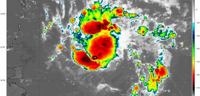
Tropical Storm Dorian Intermediate Advisory Number 10A
NWS National Hurricane Center Miami FL AL052019
800 PM AST Mon Aug 26 2019
…DORIAN NEARING BARBADOS…
SUMMARY OF 800 PM AST…0000 UTC…INFORMATION
———————————————-
LOCATION…13.0N 59.1W
ABOUT 30 MI…50 KM ESE OF BARBADOS
ABOUT 140 MI…220 KM ESE OF ST. LUCIA
MAXIMUM SUSTAINED WINDS…60 MPH…95 KM/H
PRESENT MOVEMENT…WNW OR 290 DEGREES AT 14 MPH…22 KM/H
MINIMUM CENTRAL PRESSURE…1007 MB…29.74 INCHES
WATCHES AND WARNINGS
——————–
SUMMARY OF WATCHES AND WARNINGS IN EFFECT:
A Hurricane Watch is in effect for…
* St. Lucia
A Tropical Storm Warning is in effect for…
* Barbados
* Martinique
* St. Lucia
* St. Vincent and the Grenadines
A Tropical Storm Watch is in effect for…
* Dominica
* Grenada and its dependencies
* Saba and St. Eustatius
* Puerto Rico
A Hurricane Watch means that hurricane conditions are possible
within the watch area, in this case, within the next 24 hours.
A Tropical Storm Warning means that tropical storm conditions are
expected somewhere within the warning area within 36 hours.
A Tropical Storm Watch means that tropical storm conditions are
possible within the watch area, generally within 48 hours.
Interests in the Virgin Islands and Hispaniola should monitor the
progress of Dorian as watches for these areas could be required
tonight or Tuesday.
For storm information specific to your area, please monitor
products issued by your national meteorological service.
DISCUSSION AND OUTLOOK
———————-
At 800 PM AST (0000 UTC), the center of Tropical Storm Dorian was
located by an Air Force Reserve Unit Hurricane Hunter aircraft near
latitude 13.0 North, longitude 59.1 West. Dorian is moving toward
the west-northwest near 14 mph (22 km/h) and this motion is expected
to continue through Tuesday night, followed by a turn toward the
northwest on Wednesday. On the forecast track, the center of Dorian
is expected to move near or over the Windward Islands this evening
and tonight and move into the eastern Caribbean Sea on Tuesday.
Dorian is forecast to pass near or south of Puerto Rico on Wednesday
and approach eastern Hispaniola Wednesday night.
Maximum sustained winds are near 60 mph (95 km/h) with higher
gusts. Some strengthening is forecast during the next few days, and
Dorian could be near hurricane strength when it passes through the
northern Windward Islands early Tuesday, and it is expected to be a
hurricane when it moves near Puerto Rico and eastern Hispaniola.
Tropical-storm-force winds extend outward up to 45 miles (75 km)
from the center.
The minimum central pressure reported by the Hurricane Hunter
aircraft is 1007 mb (29.74 inches).
HAZARDS AFFECTING LAND
———————-
Rainfall: Dorian is expected to produce total rain accumulations of
3 to 8 inches in the Windward Islands from Martinique south to St.
Vincent, including Barbados. Isolated maximum totals of 10 inches
are possible across the northern Windward Islands. Rainfall totals
of 1 to 3 inches are expected from the Grenadines, south to Grenada
and across Dominica. Rainfall totals of 2 to 4 inches with maximum
totals of 6 inches are possible across Puerto Rico and St. Croix.
WIND: Hurricane conditions are possible tonight and early Tuesday
within the Hurricane Watch area. Tropical storm conditions are
likely in the warning area tonight and early Tuesday. Tropical
storm conditions are possible within the tropical storm watch area
in the Lesser Antilles tonight or Tuesday and in Puerto Rico on
Wednesday.
SURF: Swells generated by Dorian will begin affecting portions of
the Lesser Antilles tonight and continue into Tuesday. These
swells could cause life-threatening surf and rip current
conditions. Please consult products from your local weather office.
Dorian is expected to bring showers and thundershowers to the state of Grenada (mainly the northern parts) by Monday night into Tuesday. As such, the met office has issued a low chance of flooding for the northern part of the state by Tuesday morning.
Citizens are advised to closely follow the advisories issued by NaDMA and adopt all necessary measures to preserve life and property.
NaDMA together with the technical advice of the Meteorological office will continue to monitor Tropical Storm Dorian and update the public.
